


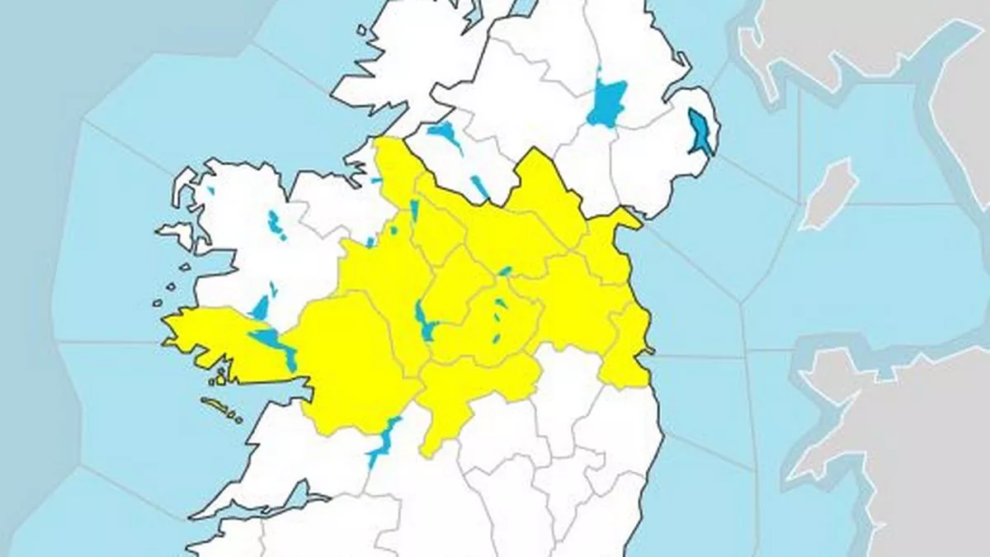
Met Éireann has issued a status yellow thunderstorm warning for 11 counties this afternoon.
The warning for counties Carlow, Dublin, Kildare, Kilkenny, Laois, Offaly, Wexford, Wicklow, Cork, Tipperary, Waterford lasts until 9pm this evening.
The national forecaster said there could be a “moderate chance of thunderstorms this afternoon and evening with a possibility of hail”, with possible spot flooding, poor visibility and difficult travelling conditions.
Met Éireann has warned of heavy rain and the chance of some thunderstorms today amid a mix of sunny spells and showers.
Earlier the forecaster said thunderstorms and very heavy downpours may develop in the south and east this afternoon – before drier intervals will spread from the northwest this afternoon.
High temperatures will range from 14 to 18 degrees today coolest in the northwest with moderate west to northwest winds.
“Heavy showers in the southeast will clear early in the night leaving however further light showers [that] will spread from the Atlantic over the west of the country, but turning largely dry with clear spells in the east. Lowest temperatures of 6 to 11 degrees, in light west to southwesterly winds with a few mist patches in places too,” Met Éireann said.
Tomorrow will again see a mix of showers and spells of sunshine with some of the showers turning heavy at times in the afternoon. Again highs will range from 14-18, coolest along the Atlantic coast.
The outlook for the rest of the week remains unsettled but it will begin to get warmer towards the weekend.
“[Thursday will be] mostly cloudy with just a few hazy bright spells in the east during the morning. Outbreaks of rain in the west will turn heavy and persistent at times, while patchy outbreaks of rain will gradually spread east later in the day. South to southeast winds freshening too and increasing strong near the west coast. Highest temperatures of 15 to 19 degrees, warmest in the east.
“There is more uncertainty for Friday however currently it looks as if the west will see heavy or thundery showery outbreaks of rain continue, with drier brighter conditions in the east, however there is still the potential for showery rain to spread further east also. It will be a warm and humid day with highest temperatures of 18 to 22 degrees in moderate to fresh southeast winds.
“Outbreaks of rain look to continue overnight mostly in the south and west with drier clearer conditions to the northeast. Lowest temperatures of 12 to 15 degrees in moderate to fresh southeast winds,” Met Éireann said.
Saturday will be showery and blustery to start but conditions will improve as the day progresses with highs of 18 to 22 degrees.
Showery and unsettled conditions look set to continue on Sunday and for the early days of next week with highs in the upper teens or low 20’s,” Met Éireann said.
Source : independent.ie